
On August 11, 2010, a major wireless milestone passed largely unnoticed: the end of a tumultuous twelve year regulatory process to authorize ultra-wideband (or “UWB”) wireless systems. The FCC ordered ET Docket No. 98-153 “TERMINATED.” By dismissing the last outstanding Petitions for Reconsideration, the FCC has finally and firmly secured […]
RTLS
75 posts
High Frequency Direction Finding (HF/DF or “Huff-Duff”) played a critical role in the Second World War. Shore based DF determined the location of German U-boat packs enabling convoys to be routed around them. Ship and airborne DF in conjunction with centimetric radar enabled effective antisubmarine warfare. [1, 2] One of […]
The Boston Globe has a great article on Q-Track’s successful firefighter rescue demonstration at WPI earlier this month: WORCESTER — The blinded, disoriented firefighters who crawled up the stairs of a century-old brick building here recently had to find a missing colleague, and find him fast. Their only hope was […]
It’s been a busy week, so here is yet another RTLS/RFID update: Mark Roberti of RFID Journal has a new blog entry on the RFID Privacy Conundrum. From the Daily Californian, New Backpack Makes 3D Maps of Buildings H/T: Ericsson Labs Harris unveils firefighter location system. H/T: Stephen J. Crowley […]

Conventional RTLS typically relies on one of three general approaches: Direction Finding (DF): originated by John Stone Stone in 1902, Amplitude Ranging: originated by Lee de Forest in 1904, and Time of Flight (Time Difference of Arrival (TDOA), or Transponder Ranging are typical approaches): orignating in the 1920’s and 1930’s. […]
A few RTLS and Location Based Services updates: First, a nice introduction to Location Based Services from ComputerWorld. An explanation of Facebook’s new Location Based Service from the New York Times. Yet another Location Based Service launched yesterday: “Qilroy,” a Qualcomm Service Labs incubated project. Precise Path has a precision […]
Last month, a Q-Track team traveled to the historic Safety Research Coal Mine in Bruceton, Pennsylvania to conduct RF propagation and performance tests on a Near-Field Electromagnetic Ranging (NFER®) Real-Time Location System (RTLS). We optimized the system for use in a mine environment in an effort funded by NIOSH. We […]
The organizers of Fifth Precision Personnel Locator (PPL) Workshop (held on the campus of Worcester Polytechnic Institute, or WPI, August 2-3, 2010) collaborated with the Worcester Fire Department to conduct realistic firefighter rescue exercises. All three systems tested enabled rescues substantially faster than the 24 minute unaided rescue baseline. The […]
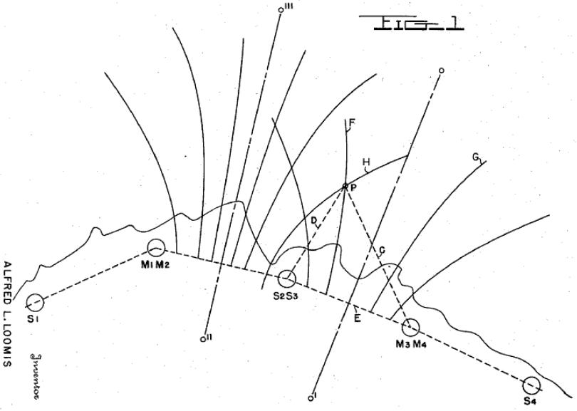
The Second World War spurred further innovation in RF-based navigation. The first wide-scale deployment of an RF-based location system was the Long Range Navigation or “LORAN.” LORAN was an evolution from a shorter range British system called “GEE.” Like GEE, LORAN employed synchronized impulse signal transmissions from paired transmit towers. […]
Here are a few RTLS and RFID news updates… Here’s a great article in xconomy|Boston on RFID innovator, ThingMagic. ThingMagic co-founder, Matt Reynolds, was one of the first to consider using low frequency signals for indoor location. He’s now a professor at Duke University pursuing an interesting line of research […]
The proceedings of the Fifth Precision Personnel Locator (PPL) Workshop, held on the campus of Worcester Polytechnic Institute (WPI) August 2-3, 2010, are now available online. The agenda includes links to most of the presentations. A copy of Q-Track’s Firefighter Location and Rescue Equipment (FLARE) presentation (Near-Field Electromagnetic Ranging (NFER®) […]
The Huntsville Times has a great write-up on Q-Track’s recent successful test of prototype Firefighter Location and Rescue Equipment (FLARE): HUNTSVILLE, AL — Q-Track, a wireless tracking technology company in Huntsville, unveiled its firefighter location system prototype last week in Worcester, Mass., where six firefighters died in a warehouse fire […]
You have no right to privacy in public places, and police can observe you to gather evidence without a warrant. But having a detective tail you everywhere you go is expensive. So why not automate the process by hiding a compact GPS tag to monitor your location? The system can […]

It was a busy couple of days at the 5th Annual Workshop “Precision Indoor Personnel Location and Tracking for Emergency Responders” at Worcester Polytechnic Institute in Worcester, MA. Q-Track (Facebook) unveiled our FLARE (Firefighter Location and Rescue Equipment) prototype system on Monday. Yesterday we participated in a realistic fire rescue […]
I’m with the Q-Track team at Worcester Polytechnic Institute in Worcester, MA today attending the 5th Annual Workshop “Precision Indoor Personnel Location and Tracking for Emergency Responders.” Q-Track will be debuting our “Firefighter Location and Rescue Equipment” concept in a presentation at 11:20am (ET). I’ll provide addditional updates as time […]
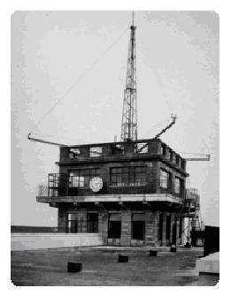
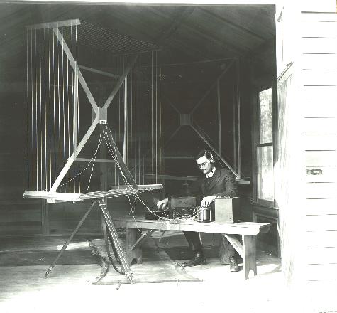
By the 1920’s direction finding was well-advanced, and DF techniques began to see everyday use in both marine and aerial navigation. [1] The Figure shows a DF array from around 1930 deployed at Croyden Aerodrome in the UK [2]. Another good example of a sophisticated and relatively simple to use […]
Under optimal conditions during daylight hours, direction finding (DF) accuracy could be as good as one to two degrees (300m at 10km range). [[1]] At night, however, the ionosphere reflects distant signals from over the horizon. The resulting “skywave” signals have a mix of vertical and horizontal polarization components that […]
Zebra Enterprise Solutions announced last week that they will be releasing the DART Ultra-Wideband (UWB) Real-Time Locating System (RTLS) this Fall. Zebra acquired UWB pioneer MSSI in 2008.
In 1902, a reporter asked Guglielmo Marconi about the vulnerability of wireless signals to interception. Marconi reassured the journalist, “It isn’t possible without a special installation and without guessing the frequency.” [[1]] The First World War demonstrated the magnitude of Marconi’s error. The Russian Army began the war sending signals […]
Huntsville, AL based Intergraph agreed Wednesday to be purchased by Swedish measurement technology company Hexagon AB for $2.3 billion, according to the Wall Street Journal. Intergraph, a leading geospatial and CAD software company, will remain a separate division of the company. Local coverage and comments are here.
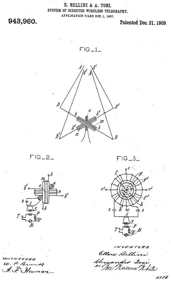
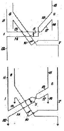
Ettore Bellini (1876-1943) and Alessandro Tosi devised a much improved direction-finding system in 1907. [[1]] Their scheme deployed two orthogonal arrays similar to those of Stone. The key advantage of the Bellini-Tosi direction finder was a rotating transformer coupling. Rather than rotate a potentially large antenna system, the Bellini-Tosi system […]
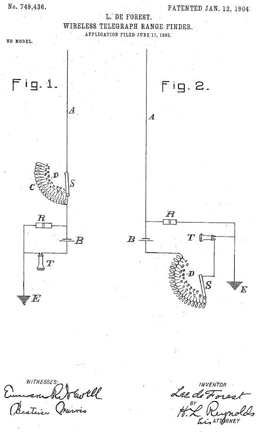
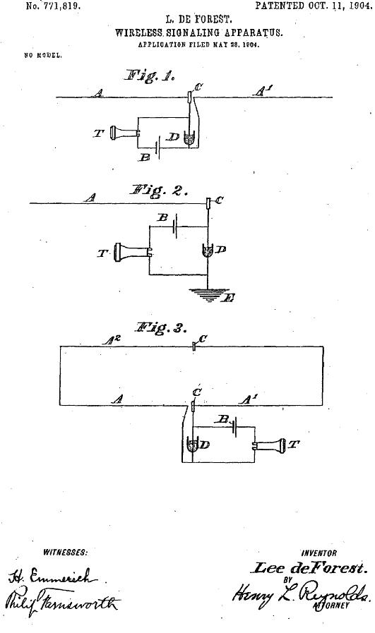
A prolific inventor, Lee de Forest not only invented some of the first direction finding (DF) antenna systems, but also deserves the credit for having invented the first RF ranging system. Realizing that signal strength declines with distance, de Forest proposed inserting a variable resistor into the RF circuit to […]
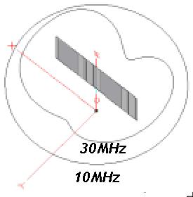
John Stone Stone (1869-1943) patented the first effective direction finding system in 1902. [[1], [2]] Stone’s scheme involved a two element antenna with a first element (V) arranged no more than a half wavelength away from a second element (V’). The Figure below shows Stone’s invention. The two elements are […]
Communications may have been the first commercial application of wireless technology, but Real-Time Location Systems (RTLS) were close behind. In the first few years of radio, a variety of aggressive inventors recognized the problem of RTLS and leaped to offer solutions. Some of their ideas illustrated the inventors’ misunderstanding of […]