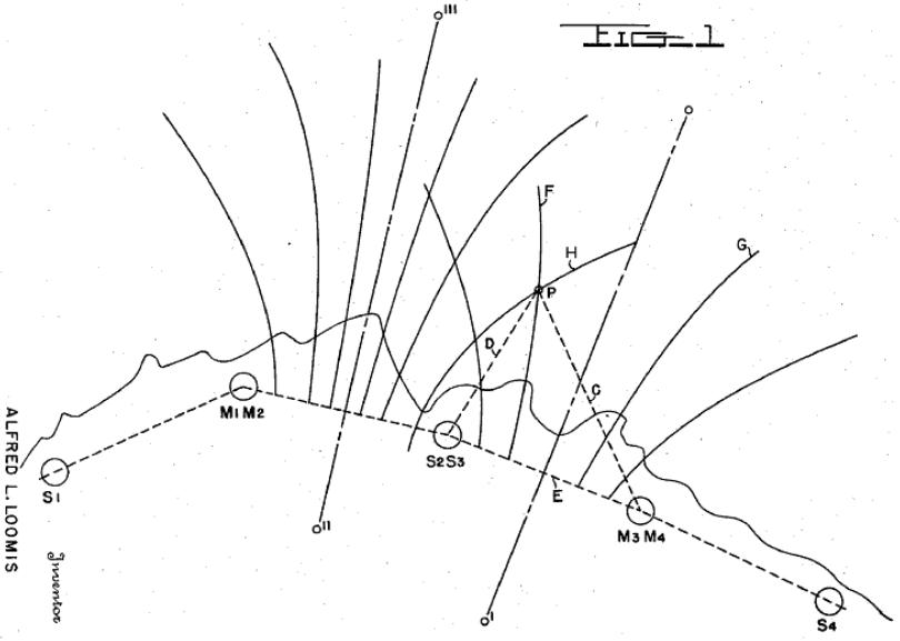
The Second World War spurred further innovation in RF-based navigation. The first wide-scale deployment of an RF-based location system was the Long Range Navigation or “LORAN.” LORAN was an evolution from a shorter range British system called “GEE.” Like GEE, LORAN employed synchronized impulse signal transmissions from paired transmit towers. By measuring the Time Difference of Arrival (TDOA) of the paired signals, users could determine which of a family of hyperbolic curves passed through their location. The intersection of two such curves defines the user’s location. The Figure illustrates two overlapping families of hyperbolic curves. Each curve denotes a line of constant TDOA for signals from a pair of stations. Two measurements of TDOA yield the 2-D position of the receiver.

The LORAN system was conceived by Alfred Lee Loomis during the war. [1] In his classic memoir, Radar Days, “Taffy” Bowen described how he explained GEE to Loomis one evening and by the next morning, Loomis had conceived of the idea of operating a TDOA location system at a low enough frequency to exploit ionospheric or skywave propagation beyond the horizon. [2] The patent rights to the system were a subject of prolonged wrangling. [3]
The original LORAN-A system operated in the band 1750-1950kHz, within the 160m amateur radio band, just above the commercial AM broadcast band (530-1710kHz). LORAN-A had a range under 1000km. The frequencies used made it vulnerable to interference between ground wave and sky wave propagation, particularly at night. LORAN-A ceased operation late in 1980. A higher accuracy version, LORAN-C, began development in the 1950’s. Operating in the band from 90-110kHz, LORAN-C yields absolute accuracy of about 185-463m with repeatability of 18-91m. Range depends on the signal-to-noise ratio, but could be as far as 1100km. U.S. LORAN stations, largely redundant with the availability of GPS, ceased transmission in August 2010. A very readable discussion of LORAN including its history and technical details is available elsewhere. [4]
[1] Alfred Lee Loomis, Long Range Navigation System, U.S. Patent 2,884,628, April 28, 1959.
[2] E.G. Bowen, Radar Days,
[3] Jennet Conant, Tuxedo Park : A Wall Street Tycoon and the Secret Palace of Science That Changed the Course of World War II, (New York: Simon & Schuster, 2002), pp. 231-237, 265-267, 272-273, 285.
[4] Luke Melton, The Complete Loran-C Handbook, (Camden, Maine: International Marine Publishing Company, 1986).


